Bet Guvrin National Park
Legend
Description of the site
Chronicles of Maresha
Chronicles of Bet.Guvrin
Archeology Research
The recomended Tour
The long route (3-4 hours)
The short route (2 hours)
Sites in the Park
15 The Northern Complex
Pictures (my visit)
1.Sites 1-15 (the caves-316 pictures)
2. The Roman Amphitheatre


updated: 08.04.09 19:17
map
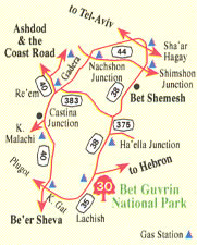
The National Park extends over 500 hectares and within its boundaries are located the ancient cities of Maresha and Bet-Guvrin with their many caves. The site is located in the basin of the Guvrin Stream, at the point of transition between the Low Shephela and the High Shephela, at an altitude of 820-1,150 feet above sea level.
In the valleys between the hills lies the agricultural area; local water sources too, are found here. An important road junction was found here, serving the intersecting highways, which extended the length of the Shephela from north to south and from west to east, from the Coastal Plain to the mountains of Hebron and Jerusalem.
The bedrock here is soft limestone ("kirton") tens of feet thick. Above it, weathering has created a cap of harder limestone ("nari") 5-10 feet thick, which had to be removed in order to dig out the kirton underneath it. The softness of the natural bedrock enabled the digging out of a great many caves, varied in size and use. The rock quarried out of the caves was cut into building stones, while many of the hollow spaces left behind were utilized as industrial installations, water reservoirs, storerooms, for keeping cattle and beasts of burden and as burial caves.

Maresha is mentioned among the cities of Judea noted in Joshua 15 :44 ("... and Mareshah"), and as one of the cities fortified by Rehoboam against the incursion of Babylon into his kingdom: 'And Rehoboam built cities for defence in Judah.He built even Bethlehem ... and Mareshah ..." (Chronicles 2, 11 i 5-8). At the beginning of the 9th century B.C.E., Zerah the Ethiopian attacked Judea and engaged King Asa in the Maresha area: "And there came out against them Zerali tlhe Ethiopian ... Asa went out against him, and they set the battle in array in the valley, Zepphathah to Mareshah" (Chronicles 2,14:8-10).
During the Persian period, after the destruction of the First Temple, Maresha and all of southern Judea was settled by Edomites, who came from the southeast. At the end of that period (in the 4th century B.C.E.), Sidonians and even Greeks came to Maresha, bringing the Hellenistic culture with them. In additional, isolated Egyptians and a few Jews lived there - refugees from the fall of the Temple and emigrants from the Coastal Plain. Thus was created the special fabric of society in this Hellenistic city, which was an important economic center. During the same period, the Lower City was built, and in it many caves were hewn..
From historical sources and local excavations it became evident that in 113/112 B.C.E., John Hyrcanus I, the Hasmonean, conquered Maresha and converted the residents of the city and its surroundings to Judaism. The upper and lower city became desolate ruins. However, Maresha recovered and was repopulated, but its settlement was sparse, and according to Josephus Flavius, it was finally demolished by the Parthian Army in 40 B.C.E.

Bet-Guvrin replaced Maresha as the most important settlement in the area. It is mentioned for the first time in ancient literature by Josephus Flavius in 68 C.E. as one of the towns conquered by the Roman general Vespasian. Following the destruction of the Second Temple, it continued to exist as a rather crowded Jewish settlement until the Bar-Kochva Revolt, 132-135 C.E.
In 200, Emperor Septimus Severus changed Bet-Guvrin's name to Eleutheropolis (I/City of the Freel/) and granted it municipal status. Two aqueducts brought water from afar, and together with local waterworks, supplied the needs of the residents. Five highways, all marked with milestones, led to the city from various directions. Besides dwellings, the city boasted an amphitheater and public buildings. The Jewish settlement was rehabilitated, and in the 3rd-4th centuries, Bet-Guvrin was mentioned in the Talmud and the Midrashim - Commentaries on the Scriptures - and by its sages such as Rabbi Yonatan and Rabbi Yehuda Ben-Yaakov.
From the Roman and the Byzantine periods, a large Jewish cemetery and architectural remains were discovered, as was a synagogue inscription. During the Byzantine period, Bet-Guvrin was an important center of Christianity with a number of churches. Most of the bell caves were dug during the Early Muslim period, and finds from the Crusader period indicate that it was a small fortified city, at the hub of which was a church dedicated in 1136. The city was surrounded by Crusader villages, and apparently the Church of St. Anne was restored at about the same time.
An Arab village occupied the site until Israel's War of Independence (1948). In June that year, the Egyptian Army occupied the British Taggart Fort built there at the outset of World War II. On October 27 1948, Israeli forces recovered the area, and in May 1949 Kibbutz Bet-Guvrin was established on the site.
In 1900 the famed archaeologists Bliss and Macalister conducted extensive excavations in Maresha on behalf of the British Palestine Exploration Fund. In 1902 Thiersch and Peters investigated the two Sidonian burial caves southeast of the Tel. In the Sixties and Seventies, surveys were carried out by the Israeli geographer Ben-Arieh and archaeologists Oren, Dagan, Kloner and others. Broad-based excavation and research acrivities on behalf of the Israel Antiquities Authority by Prof. Amos Kloner began in 1989, and are still being conducted.
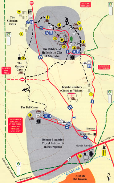
The Park comprises the following Visitors' Areas:
-Tel Maresha and the houses and caves of the lower City (No. 2-7, 10-12)
-Sidonian Burial Caves (No. 8-9) . Tel Cemetery and Church (No.1, 13) .
- Tel Bell Caves of Bet-Guvrin (No. 14)
We travel by car 0.8 mile southward along a rising road, bearing left to Parking Lot A.
Here we leave the car and walk 0.9 mile to caves 2-9.
The car shold be moved to Parking Lot C, or returned to at the end of the tour. If you are traveling in two cars, one may be left in Parking Lot A, the other in C.
From Cave 9, return to the car on the same path, and continue to the Bell Caves (14).
In the car, we come to Parking Lot A. From here we take a walking tour to the HPolish CaveN and Columbarium (2-3). We then travel half a mile to Parking Lot B. After visiting a series of caves (6), we travel another 0.3 mile down the hillside to Parking Lot C and visit the painted Sidonian Cave. Returning to the car, we will ride another 0.9 mile to Parking Lot D and visit the Bell Caves.
Northern Cemetery of Maresha (1)
Dated to the 3rd and 2nd centuries B.C.E. In it were discovered two caves of burial niches. Adjoining them are the rear sections of two additional caves. A bell cistern dug out later, damaged these caves.
The "Polish Cave" (2)
A water cistern, which was dug during the 4th-3rd centuries B.C.E. Later it was converted into a columbarium for raising pigeons. During World War II, the place was visited by Polish soldiers of General Anders' army, who cut into a supporting pillar (of which only the bottom half remains) the year of their visit - 1943 - the words "Warsaw, Poland" and an eagle, symbol of the Polish Army.
The Columbarium Cave (Pigeon Coop Cave) (3)
was built in the shape of a double cross, and is the largest and most beautiful in the country. More than 2,000 niches in it. In the niches, pigeons were raised for cultic purposes and for food, and their dung was used as fertilizer. The columbarium went out of use at the end of the 3rd century B.C.E., and the niches were used for storage. In the region, 85 such installations were discovered, containing tens of thousands of niches.
The Bath Cave (4)
Comprises a flight of stairs and two small room lets containing seats for the convenience of the bathers, who showered in sprays of water emerging from jets in the bedrock wall. The bather was invisible to the slave pouring the water, and thus his modesty was preserved. It is quite probable that the washing of the body was involved in some cultic rites. In Maresha, upward of twenty rock-hewn installations have been discovered, which served as baths in the 4th-3rd centuries B.C.E.
The Olive Oil Plant (5)
Seen here is one of 22 subterranean 01 ive oi I plants from the 4th-3rd centuries B.C.E. thus far discovered at Maresha.ln most of them is one crushing installation and two or three lever-and- weights presses for extracting the oil from the olive mash. Growing olives and producing oil comprised and important branch of the economy in the Shephela of ancient times. Olive groves occupied huge areas of the lands surrounding the city. Olives were harvested in the Fall, and for two or three months following, the oil plants worked during most hours of the day in order to achieve maximum output. Mashing the olives in the crushers took about half an hour, and the oil was expressed in a few hours. The oil fulfilled a number of needs: illumination, cooking, nutrition, preserving food, cultic ceremonies, oiling the body and cosmetics, while the olive waste - the "gefet" - was used mainly as heating fuel.
The Dwelling House (6)
The house, partly restored, was used as a dwelling and for trade during the Hellenistic period (3rd-2nd centuries B.C.E.). The ground floor occupies about 1,600 square feet, and its rooms were arranged apound a small central courtyard. Ascent to the second floor was by a flight of steps. The walls of the house survived to a height of 5 feet, and were long ago plastered to preserve their soft limestone. Some of the reconstructed walls were made of excavated building stones. Under the floor of one of the rooms was discovered a hoard of 25 coins, the latest of which was stuck in the year 113 B.C.E. From this it is deducted that the house was destroyed that same year, when Maresha was conquered by the Maccabees under John Hyrcanus I. There are cisterns under the house in which rainwater, collected from the alleys, roofs and courtyards, was stored. It flowed through ceramic pipes and channels along the length of the stairs. The householders descended into the cisterns by means of a railed flight of stairs. Behind the broken wall of one of the cisterns was found a broad quarry with stanchions supporting its ceiling, from which there is presently a passageway to the cisterns of another house.
Dwelling Houses and Underground System (7)
(Hellenistic period 3rd-2nd centuries B.C.E.). Through the northern house, one may descend to a bath, remarkable both in its design and in its state of preservation. The underground route leads to a group of cisterns, continuing through the columbarium to additional rooms and cisterns. The olive oil plant and its adjacent chambers are underneath the fourth house, the last in the row. In the past, the many underground chambers were used separately- there was no passageway connecting them.
The Sidonian Burial Caves (8-9)
During the 3rd-2nd centuries B.C.E., the Mareshans habitually interred their deed in niches within gabled burial caves (i.e., with a triangle above the crypt). In cave 8, where the original paintings have been restored, appears an inscription mentioning Apollophanes, son of Sesmaios, leader of the Sidonian community in Marissa. The inscription and paintings shed light on the art, mythology and zoological erudition of the period, as well as the ethnic group of those interred (Edomite, Sidonian or Greek), family ties, burial customs and more. 260 feet south of this cave is located another, in which a painting of musicians has been restored. The caves were discovered in 1902 and published by the archaeologists Thirsch and Piters in 1905. In 1993 the original paintings were restored in accordance with their sketches.
The Southeast Observation Point (10)
From the corner of the Tel, one may look out over the Eastern Shephela and Hebron Mountains.
The Northwestern Tower (11)
In the corner of the upper city, a huge square tower was discovered. The tower was constructed in two stages: the lower section in the 3rd century B.C.E., and the upper in the 2nd century B.C.E. The Tower is surrounded on the West and North by a wall, that was built during the period of the judean Kingdom, predating it by several hundred years and serving as a retaining wall of the foundations of the Tower in the Hellenistic period.
Shops and houses (12)
North of the Tower were found elaborate buildings-courtyards, stairwells and rooms, apparently used for business and housing during the Hellenistic period. On the lower floors of the houses, six stores or workshops were discovered, arranged in a row. These houses abutted the Iron Age walls which surrounded the Tower.
The Church of "Sandahanna" (St. Anne) (13)
With an area of 170 x 184 feet, was built during the Byzantine period, and renovated - although with a smaller perimeter - during the Crusader period. The Latin name "Santa Anna", mispronounced "Sandahanna", became the Arabic name of Tel Maresha.
The Bell Caves (14)
Located within the boundaries of Bet-Guvrin, and date to the Byzantine and Early Muslim period. Originally there were some 80 bell-shaped pits, connected by passageways to become vast underground networks. In the entire area there were about 800 Bell Caves, the maximum depth of which is 82 feet, and most of which were 40-50 feet deep. At first it was thought that the caves were used as water reservoirs, storehouses, dwellings and bunkers. Today, however, it is clear that most of them were quarries, which supplied building materials to the cities of the Coastal Plain and to Bet-Guvrin itself. EI-Muquadasi, a 10th century Arab historian, wrote of Bet-Guvrin: 'It is a land of richness and plenty, and in it are man!! marble quarries..." Quarrying was carried out through a narrow opening, and the perimeter of the pit broadened during the operation. This was done for several reasons: to ensure the pit against collapse, to prevent the limestone from drying out, to protect the quarrymen from climatic hazards and to provide them with a clear rounded contour for their progress, both safe and easy to quarry. The stone blocks were raised and removed from the cave by means of ropes. From the inscriptions in Arabic, it is obvious that these were Christians fluent in Arabic. Most of the quarrying was done from the 7th to the 10th centuries C.E.
The Northern Complex of Beit Govrin
The fortress, the Church and the Amphitheater (15) - A Roman amphitheater was completely exposed in northwestern end of the town of Beit Govrin. Fights between gladiators, slaves and beasts of prey took place in this amphitheater. Two crossing tunnels under the arena served probably as cages for the animals which were brought up to the arena by an elevator. In the Byzantine period the amphitheater served as a public market. Parts of a large Roman bathhouse were exposed east of the amphitheater. It includes several impressive arches and the Cauldron ("the hot room"). In the 12 century C.E. a large (about 130x180m) Crusader fortress was built on top of the amphitheater and the bathhouse surrounded by a moat. In its center there was an inner fort (56x58m) with several arches and a mess hall. Attached to the fortress, to its south there is a church with two rows of columns. and three niches ("aphsides") facing east. Several structures were added in the inner fort, in the Mamluk and Ottoman eras, including a mosque.