| Bet She'an National Park | ||||||||||||||||||||
| Description of the site | ||||||||||||||||||||
| Historical Background | ||||||||||||||||||||
|
||||||||||||||||||||
| Pictures (my visit) | ||||||||||||||||||||
|
|
||||||||||||||||||||
|
updated:
16.04.09 8:37
|
||||||||||||||||||||

 |
The Bet She'an National Park, which extends over an area of 400 acres, includes the ancient city of Bet She'an-Scythopolis and the imposing Tel BetShe'an. Archaeological excavations were first carried out in Bet She 'an in the 1920s. Major excavations have been going on since 1986 in the framework of a joint enterprise run by the Antiquities Authority and the Hebrew University. The archaeological excavations, which have uncovered about one tenth of the city's area, are accompanied by architectural reconstruction of buildings, installations and streets. |
Settlement of Bet She 'an first began in the fifth millennium B.C.E. on the Tel rising to the south of the Harod River, in the heart of a fertile area enjoying an abundance of water and located on a major crossroads. |
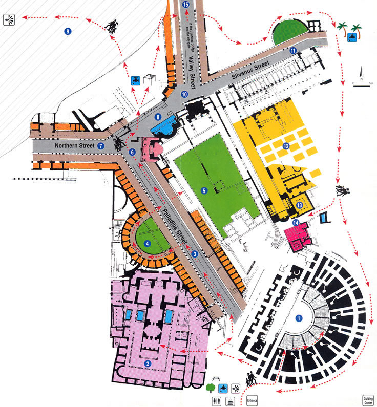
| Theater Built in the 1st century C.E., the 7,OOO-seat theater seen today is the product of renovations carried out at the end of the 2nd century. It continued to function throughout the Byzantine period. The theater had three tiers of seating, of which only the lowermost was preserved intact. Rising behind the stage was a 20-meter scaenae frons - an elaborate backdrop wall, comprising a row of imported granite and marble columns adorned by ornate capitals, a richly decorated entablature and statues. |
| Western Bathhouse This Byzantine bathhouse, covering around 9 dunams, contains hot and tepid bathing halls with a heating system (hypocaust). Its walls were coated with colored plaster and its floors were paved with marble slabs and mosaics. The main structure opens on all sides onto rooms and exedras. Frequent changes made to the building, with the funding of the province's governors, are documented in Greek dedicatory inscriptions. |
| "Palladius Street" The 150-meter long colonnaded street crossed the city from the slopes of the Tel to the theater. Originally built during the Roman period, the street was renovated at the beginning of the Byzantine period. On its northwest side is a covered portico which opens onto a row of shops whose facade was faced with marble. A dedicatory inscription from the 4th century C.E. found in the portico mosaic, recounts the construction of the portico in the days of Palladius, governor of the province. Thus the road came to be named Palladius Street by excavators. On the opposite side of the street, a two-story row of shops was erected on an ancient foundation from the Roman period. |
| Sigma A semicircular concourse of the Byzantine period, referred to as the Sigma in an inscription found at the site, surrounded by rooms opening onto it. Several of these rooms were paved with colored mosaics displaying geometric, plant and animal motifs as well as Greek inscriptions. One mosaic medallion depicts Tyche, guardian goddess of the city, wearing a crown of city walls and holding a cornucopia. |
| Roman Temple The semicircular temple, built in the 2nd century C.E. and destroyed during the Byzantine period, was in the classical style. The structure's adornments, imposing in size and ornate in style, were found collapsed nearby. Its facade consisted of four columns surmounted by capitals, supporting an ornamented gabled roof to a height of about 15 meters. Two collapsed columns were found in the ruins left by the earthquake of 749 C.E. |
| Northern Street A colonnaded street of the Roman period, leading to the northwest city gate. A staircase ascended from the street to the Tel, which served as the Acropolis of the city. On the other side was a resplendent passage to a large Roman compound, surrounded by columns (a temple?). During the Byzantine period, most of the columns were taken down and a public building paved with mosaics was erected on the spot. |
| Nymphaeum A public fountain of the 2nd century C.E., remodeled in the 4th century. Water spilled into a pool situated in front of the structure, on the side facing the street. Decorative elements found at the site await incorporation in future reconstruction of the Nymphaeum. |
| "Valley Street" and the Centra! Monument The street was paved during the Roman period along the valley of Nahal Amal, leading from the center of the city to the northeast gate (No. 15). Next to the junction, opposite Valley Street, .' is the Central Monument - a platform decorated with niches on which stood marble columns. Covered sidewalks and stores were built on both sides of the street. The street's colonnades collapsed in the earthquake, and a residential quarter was built over them during the Abbassid period. |
| “Silvanus Street” Originally, the street was a Roman road flanked on one side by a monumental. colonnade. A marble-reveted pool was built parallel to the road. During the Byzantine period, this Roman road was overlaid by a new street, and a new hall was erected on top of the poo..!, its ceiling supported by the colonnade. This street was named "Silvanus Street" by the excavators after a lawyer named Silvanus, mentioned in inscriptions as having been involved in the hall's construction. In the Early Muslim period, this hall fell into disuse, and was replaced by stores fronted by a portico of columns and arches. The earthquake of 749 C.E. leveled columns and structures along the street. A segment of the stores' facade has been restored and reconstructed, but the portico's arches still lie in the heap of ruins. |
| Eastern Bathhouse The bathhouse was built in the Roman period and renovated during the Byzantine period. A caldarium and hypocaust were uncovered on its eastern side. On the western side,excavation revealed a square structure with four pillars adorned with niches at its corners, supporting a stone vault. Cold water pools attest to its apparent function as frigidarium (cold water bath hall). |
| Public lavatories Built next to the bathhouse for the benefit of theater visitors and bathhouse users, the structure encloses a courtyard decorated with columns. |
| Sacred Compound The compound, of the 1st-2nd centuries C.E., comprises a temple, altars and Nymphaeum. The temple was built on a square raised podium with a stairway leading up to it. The altars are engraved with inscriptions. |
| Byzantine Agora A concourse surrounded by porticoes at the center of the city, built in the Byzantine period, which served as a commercial center. The western portico is paved with mosaics depicting animals. |
| Tel Bet She'an (In Arabic: Tell EI-Husn - 'The Fortress Mound') Some twenty settlement strata were uncovered on the Tel, the most ancient dating from the Neolithic period (5th millennium B.C.E.) and the most recent, from medieval times. Discovered among the remains of the walled Canaanite city were five temples, one constructed on top of the other, public and residential buildings, a governor's house and basalt monuments with inscriptions from the period of Egyptian rule. A citadel" as well as residential and administrative buildings erected by the kings of Israel were destroyed in the Assyrian conquest. The Tel was resettled during the Hellenistic period. A temple of Zeus, some of whose column drums and Corinthian capitals can be seen, was built in the Roman period. During the Byzantine period, a round church was constructed on the summit, and in the Medieval period the Tel was surrounded by a wall. The top of the Tel provides a vantage point over the city and its surroundings. |
| The "Truncated Bridge" (Jisr el-Maktu'a) and City Gate Valley Street ran across the Harod River via a triple vaulted bridge (the "Truncated Bridge"), leading to the northeast city gate, where a marketplace was located. |